융합센서 다중객체 추적 및 예측데이터
- 분야교통물류
- 유형 이미지
-
데이터 변경이력
데이터 변경이력 버전 일자 변경내용 비고 1.0 2022-07-12 데이터 최초 개방 데이터 히스토리
데이터 히스토리 일자 변경내용 비고 2022-10-20 신규 샘플데이터 개방 2022-07-12 콘텐츠 최초 등록 소개
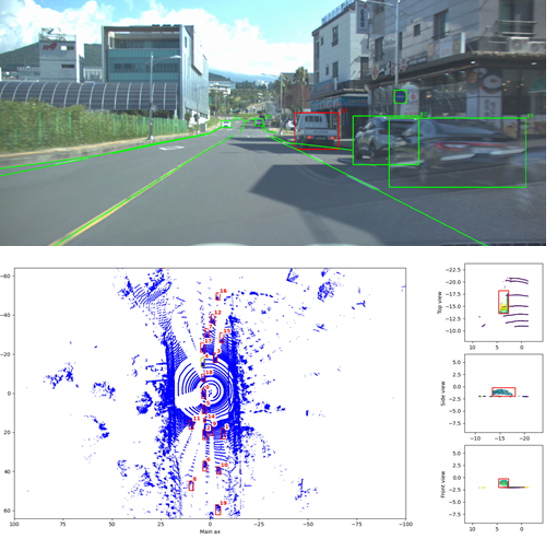
자율주행 차량 환경에서 카메라 이미지, 라이다 센서 포인트클라우드 데이터에 대해 주변의 주요 동적/정적객체를 탐지할 수 있도록 위치를 라벨링 하고 추적 id를 부여하여 추적 및 예측에 활용하도록 구축한 데이터
구축목적
완전 자율주행 연구에 필수적인 한국 주행환경에서의 융합 센서 다중객체 추적 및 예측 데이터 구축
-
메타데이터 구조표 데이터 영역 교통물류 데이터 유형 이미지 데이터 형식 jpg, pcd 데이터 출처 자체 수집 라벨링 유형 바운딩박스 (이미지), 폴리라인 (이미지), 큐보이드(라이다) 라벨링 형식 json 데이터 활용 서비스 자율주행의 탐지/추적 등 인지 요소 기술 개발 및 이를 활용한 국내 자율주행 승객이동 서비스, 배송 서비스로의 활용 데이터 구축년도/
데이터 구축량2021년/이미지 40만장, 포인트클라우드 40만장 -
1. 데이터 구축 규모
- 데이터 종류 형식
원천 데이터: 이미지(.jpg), 라이다(.pcd)
라벨 데이터: 이미지라벨(.json), 라이다라벨(.pcd) - 클래스 수량
scene별 시나리오/환경 20종
이미지 탐지 클래스 8종 (차, 이륜차, 보행자, 기타, 신호등, 표지판, 차선, 도로 경계)
라이다 탐지 클래스 4종 (차, 이륜차, 보행자, 기타) - 가공 데이터 수량
이미지 데이터: 40만장 (json)
라이다 데이터: 40만장 (json)
2. 데이터 분포
<라이다 데이터 클래스별 객체 수량>
vehicle 8,292,415
bike 118,835
pedestrian 2,314,508<이미지 데이터 클래스별 객체 수량>
traffic_light 430,912
traffic_sign 548,186
vehicle 2,958,815
bike 61,214
pedestrian 324,963
road_boundary 1,514,857
lane 2,619,612
etc 52,576
<시나리오/환경별 scene 수량>
1. 데이터 구축 규모 시나리오/환경 수량 도심/국도 (60 kph 이하) 104 고속화도로 (70kph 이상 ) 105 커브길 104 합류구간 (이면도로/차선합류) 98 선행차 추종 (가속) 104 선행차 추종 (감속) 104 선행차 컷인 101 선행차 컷아웃 103 교차로 통과 (직진) 104 교차로 통과 (우회전) 103 교차로 통과 (좌회전) 104 회전 교차로 62 전방 보행자 104 빠른 횡방향 이동 객체 101 이륜차/PM 93 주행차 차선변경 103 야간 104 악천후 93 역광 103 기타 특이상황 103 - 데이터 종류 형식
-
-
데이터 성능 점수
측정값 (%)기준값 (%)데이터 성능 지표
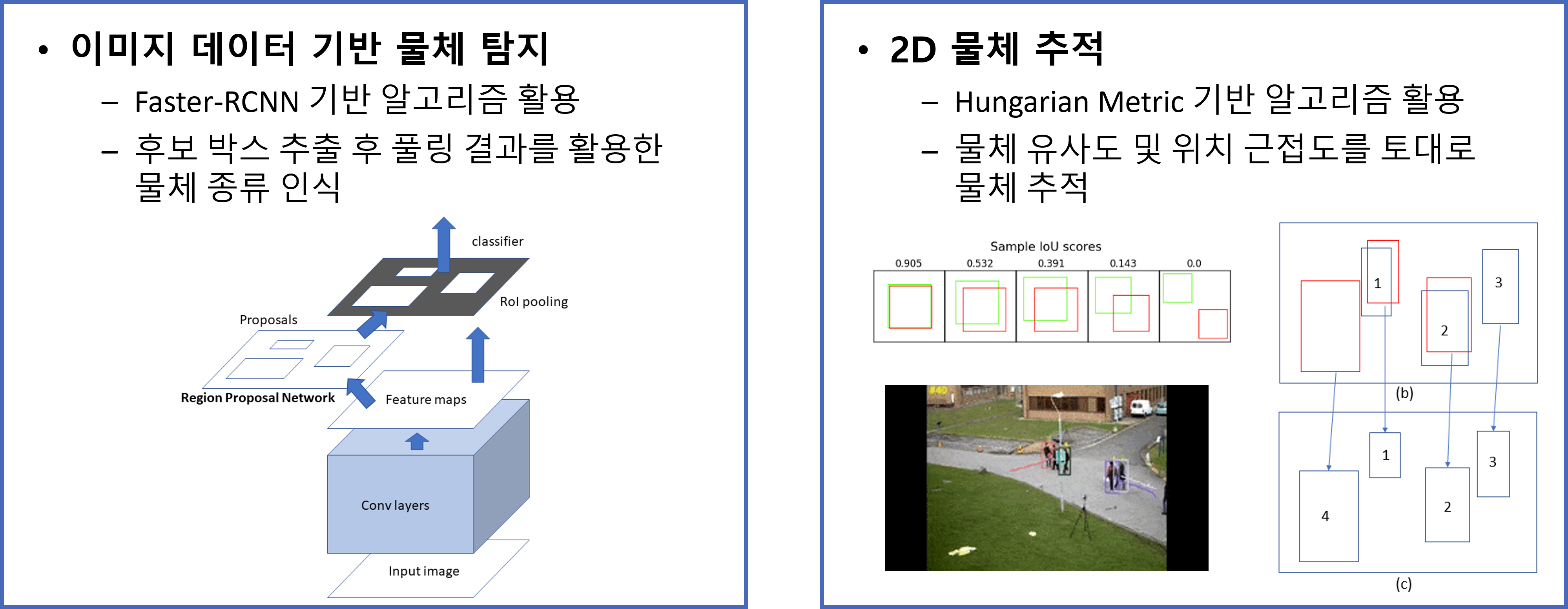
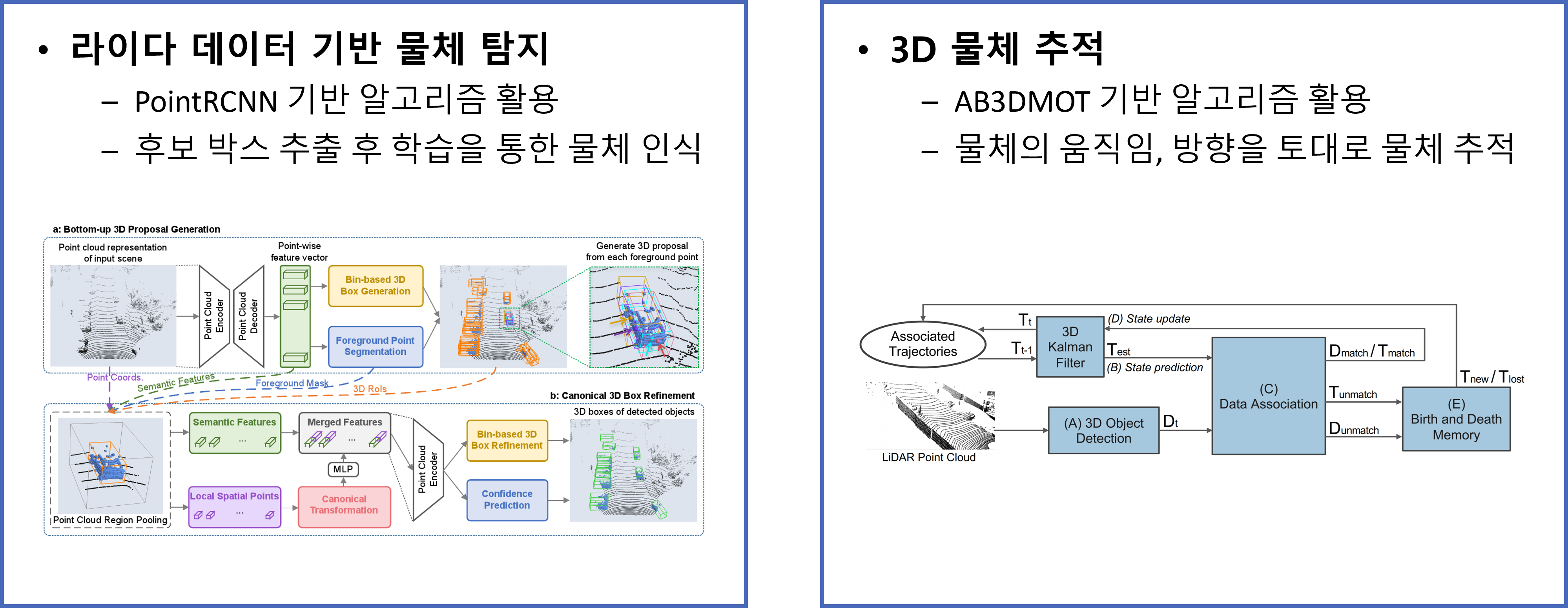
데이터 성능 지표 번호 측정항목 AI TASK 학습모델 지표명 기준값 점수 측정값 점수 1 바운딩박스 객체 인식 (신호등/표지판) Object Detection Scaled YOLO v4 mAP 50 % 82.87 % 2 바운딩박스 객체 추적 Object Detection Faster RCNN, Kalman Filter+Hungarian Algorithm MOTA 40 % 60.69 % 3 큐보이드 객체 추적 Object Detection Point RCNN, Kalman Filter+Hungarian Algorithm MOTA 40 % 64.59 %
※ 데이터 성능 지표가 여러 개일 경우 각 항목을 클릭하면 해당 지표의 값이 그래프에 표기됩니다.
※ AI모델 평가 지표에 따라 측정값의 범위, 판단 기준이 달라질 수 있습니다. (ex. 오류율의 경우, 낮을수록 좋은 성능을 내는 것으로 평가됩니다)
-
설명서 및 활용가이드 다운로드
데이터 설명서 다운로드 구축활용가이드 다운로드자율주행 차량 환경에서 카메라 이미지, 라이다 센서 포인트클라우드 데이터에 대해 자율주행 차량 주변의 주요 동적/정적객체를 탐지할 수 있도록 위치를 라벨링하고 추적 id를 부여하여 추적 및 예측에 활용하도록 구축
1. 대표도면
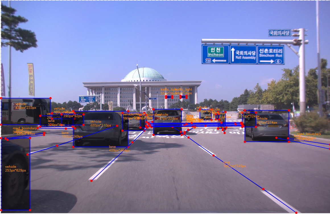
2. 라벨링데이터 구성
1. 대표도면 폴더구조 설명 원천데이터 1~20 시나리오 번호 001 ~ 폴더 번호 calib_Camera0.txt 카메라 intrinsic matrix calib_CameraToLidar0.txt camera에서 Lidar로 좌표축을 변환하는 extrinsic matrix gps_100hz.txt gnss/ins 데이터. 위도, 경도, 고도를 삭제하고, 각 scene별 원점 기준 상대 위치 image0 이미지 데이터 폴더 시나리오번호_폴더번호_파일번호.jpg lidar 라이다 데이터 폴더 시나리오번호_폴더번호_파일번호.pcd 라벨링데이터 1~20 시나리오 번호 001 ~ 폴더 번호 image0 이미지 데이터 폴더 시나리오번호_폴더번호_파일번호.json lidar 라이다 데이터 폴더 시나리오번호_폴더번호_파일번호.json 시나리오/환경 구분 번호 description 1 도심/국도 (60 kph 이하) 2 고속화도로 (70kph 이상 ) 3 커브길 4 합류구간 (이면도로/차선합류) 5 선행차 추종 (가속) 6 선행차 추종 (감속) 7 선행차 컷인 8 선행차 컷아웃 9 교차로 통과 (직진) 10 교차로 통과 (우회전) 11 교차로 통과 (좌회전) 12 회전 교차로 13 전방 보행자 14 빠른 횡방향 이동 객체 15 이륜차/PM 16 주행차 차선변경 17 야간 18 악천후 19 역광 20 기타 특이상황 - 이미지 라벨링 포맷
구분 항목명 타입 필수여부 설명 범위 비고 1 information Object 기본 정보 1-1 information[*].file_name String Y 파일명 1-2 information[*].resolution array Y 이미지 해상도 2 annotations Object 가공 정보 2-1 annotations[*].class String Y 클래스명 [vehicle, bike, pedestrian, traffic_light, traffic_sign, lane, road_boundary, etc] 2-2 annotations[*].bbox array N 가공정보 [x1,y1, 차, 이륜차, 보행자, 기타, 신호등, 표지판 x2,y2] 2-3 annotations[*].attribute Object Y 속성 2-4 annotations[*].attribute.type String N 종류 차, 이륜차, 보행자, 차선(점선,실선), 기타 2-5 annotations[*].attribute.track_id number N 트랙킹 ID 차, 이륜차, 보행자 2-6 annotations[*].attribute.instance_id number Y 객체 ID 2-7 annotations[*].attribute.right number N 브레이크 등 상태 0; 1 2-8 annotations[*].attribute.left number N 비상 등 상태 0; 1 2-9 annotations[*].attribute.break number N 좌측 방향지시 등 상태 0; 1 2-10 annotations[*].attribute.emergency number N 우측 방향지시 등 상태 0; 1 2-11 annotations[*].attribute.red number N 빨간등 상태 0; 1 신호등 2-12 annotations[*].attribute.yellow number N 노란등 상태 0; 1 신호등 2-13 annotations[*].attribute.green number N 초록등 상태 0; 1 신호등 2-14 annotations[*].attribute.x number N X등 상태 0; 1 신호등 2-15 annotations[*].attribute.left_arrow number N 좌회전 화살표등 상태 0; 1 신호등 2-16 annotations[*].attribute.other_arrow number N 그 외 화살표등 상태 0; 1 신호등 2-17 annotations[*].attribute.code String N 표지판 코드 [0~999] 표지판 2-18 annotations[*].attribute.text String N 표지판 정보 소수점 첫째 자리 표지판 2-19 annotations[*].polyline array N 가공정보 차선, 도로경계 2-20 annotations[*].attribute.color String N 색상 백,황,청 차선
- 라이다 라벨링 포맷
구분 항목명 타입 필수여부 설명 범위 비고 1 information Object 기본 정보 1-1 information.file_name String Y 파일명 2 annotations Object 가공 정보 2-1 annotations[*].class String Y 클래스명 {vehicle, bike, pedestrian} 2-2 annotations[*].attribute Object Y 속성 2-3 annotations[*].attribute.track_id number N 트랙킹 ID 차, 이륜차, 보행자 2-4 annotations[*].attribute.instance_id number Y 객체 ID 2-5 annotations[*].attribute.location array Y 위치 정보 2-6 annotations[*].attribute.dimension array Y 크기 정보 2-7 annotations[*].attribute.yaw number Y 회전축 정보 [0~π] radian
3. 라벨링데이터 실제예시
- 원천 데이터: 이미지(.jpg)
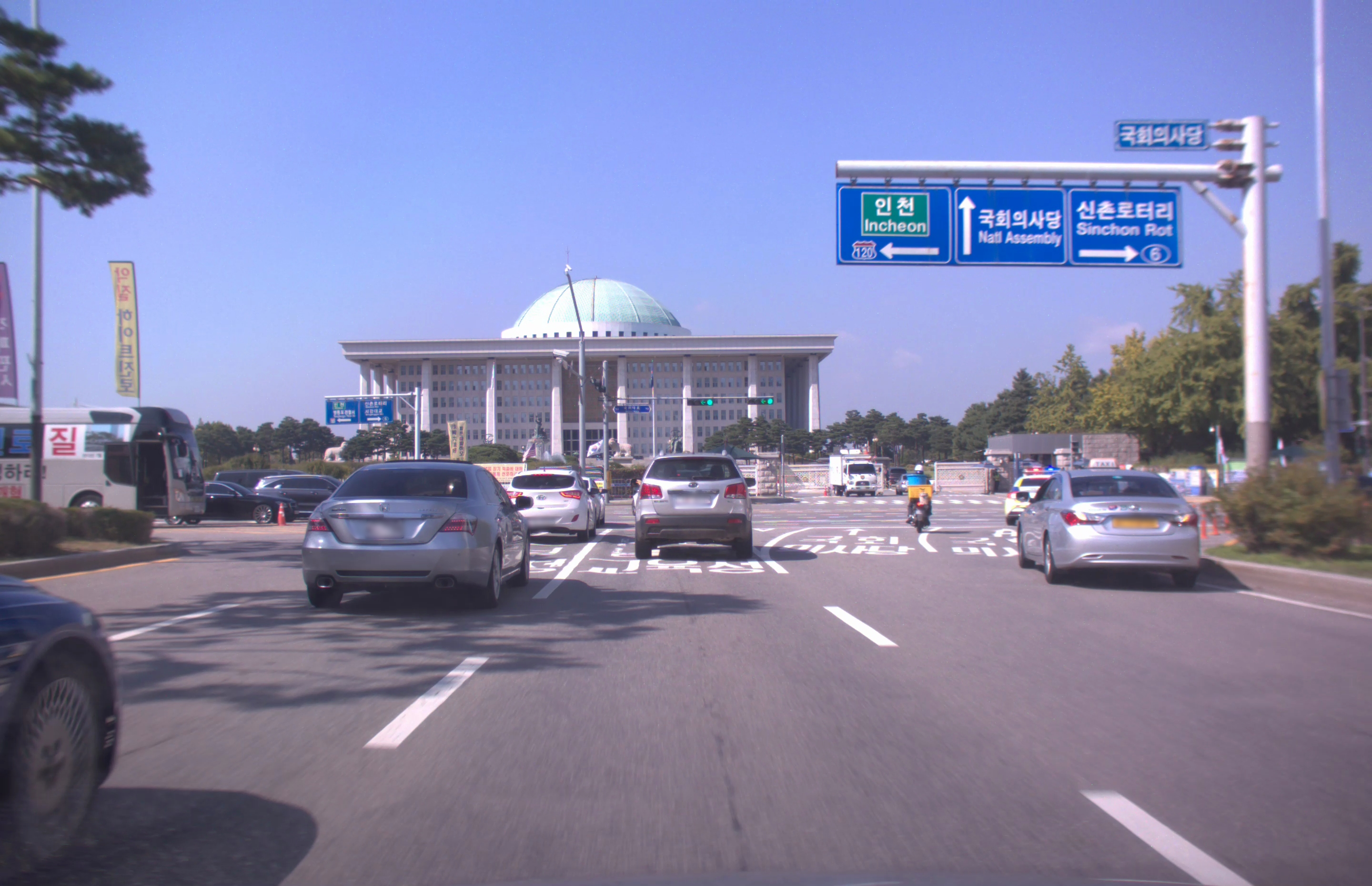
- 라벨 데이터: 이미지라벨(.json)
{
"annotations": [
{
"bbox": [
1569,
834,
1623,
850
],
"attribute": {
"red": 0,
"instance_id": 1,
"green": 1,
"yellow": 0,
"x": 0,
"other_arrow": 0,
"left_arrow": 1
},
"class": "traffic_light"
},
{
"bbox": [
1442,
836,
1497,
852
],
"attribute": {
"red": 0,
"instance_id": 2,
"green": 1,
"yellow": 0,
"x": 0,
"other_arrow": 0,
"left_arrow": 1
},
"class": "traffic_light"
},
{
"bbox": [
0,
1203,
253,
1832
],
"attribute": {
"instance_id": 3,
"break": 0,
"left": 0,
"track_id": 1,
"emergency": 0,
"right": 0,
"type": "car"
},
"class": "vehicle"
},
{
"bbox": [
2132,
960,
2519,
1234
],
"attribute": {
"instance_id": 4,
"break": 0,
"left": 0,
"track_id": 2,
"emergency": 1,
"right": 0,
"type": "car"
},
"class": "vehicle"
},
{
"bbox": [
633,
969,
1113,
1279
],
"attribute": {
"instance_id": 5,
"break": 0,
"left": 0,
"track_id": 3,
"emergency": 0,
"right": 0,
"type": "car"
},
"class": "vehicle"
},
{
"bbox": [
1333,
951,
1580,
1175
],
"attribute": {
"instance_id": 6,
"break": 0,
"left": 0,
"track_id": 4,
"emergency": 0,
"right": 0,
"type": "car"
},
"class": "vehicle"
},
{
"bbox": [
1062,
984,
1253,
1138
],
"attribute": {
"instance_id": 7,
"break": 0,
"left": 0,
"track_id": 5,
"emergency": 0,
"right": 0,
"type": "car"
},
"class": "vehicle"
},
{
"bbox": [
1220,
1001,
1271,
1110
],
"attribute": {
"instance_id": 8,
"break": 0,
"left": 0,
"track_id": 6,
"emergency": 0,
"right": 0,
"type": "car"
},
"class": "vehicle"
},
{
"bbox": [
2109,
980,
2230,
1104
],
"attribute": {
"instance_id": 9,
"break": 0,
"left": 0,
"track_id": 7,
"emergency": 0,
"right": 0,
"type": "police_car"
},
"class": "vehicle"
},
{
"bbox": [
1899,
975,
1964,
1119
],
"attribute": {
"instance_id": 10,
"break": 0,
"left": 0,
"track_id": 8,
"emergency": 0,
"right": 0,
"type": "motorcycle"
},
"class": "bike"
},
{
"bbox": [
1740,
953,
1842,
1045
],
"attribute": {
"instance_id": 11,
"break": 0,
"left": 0,
"track_id": 10,
"emergency": 0,
"right": 0,
"type": "truck"
},
"class": "vehicle"
},
{
"bbox": [
0,
853,
432,
1086
],
"attribute": {
"instance_id": 12,
"break": 0,
"left": 0,
"track_id": 11,
"emergency": 0,
"right": 0,
"type": "bus"
},
"class": "vehicle"
},
{
"bbox": [
343,
1008,
628,
1102
],
"attribute": {
"instance_id": 13,
"break": 0,
"left": 0,
"track_id": 12,
"emergency": 0,
"right": 0,
"type": "car"
},
"class": "vehicle"
},
{
"bbox": [
446,
986,
645,
1032
],
"attribute": {
"instance_id": 14,
"break": 0,
"left": 0,
"track_id": 13,
"emergency": 0,
"right": 0,
"type": "car"
},
"class": "vehicle"
},
{
"bbox": [
531,
995,
721,
1087
],
"attribute": {
"instance_id": 15,
"break": 0,
"left": 0,
"track_id": 14,
"emergency": 0,
"right": 0,
"type": "car"
},
"class": "vehicle"
},
{
"bbox": [
1879,
994,
1906,
1040
],
"attribute": {
"instance_id": 16,
"break": 0,
"left": 0,
"track_id": 16,
"emergency": 0,
"right": 0,
"type": "car"
},
"class": "vehicle"
},
{
"attribute": {
"instance_id": 17
},
"class": "road_boundary",
"polyline": [
39,
1208,
379,
1158
]
},
{
"attribute": {
"instance_id": 18,
"color": "yellow",
"type": "solid"
},
"class": "lane",
"polyline": [
56,
1218,
376,
1174
]
},
{
"attribute": {
"instance_id": 19,
"color": "yellow",
"type": "solid"
},
"class": "lane",
"polyline": [
322,
1115,
568,
1119,
646,
1117
]
},
{
"attribute": {
"instance_id": 20,
"color": "white",
"type": "dash"
},
"class": "lane",
"polyline": [
231,
1345,
490,
1268,
1014,
1096
]
},
{
"attribute": {
"instance_id": 21,
"color": "white",
"type": "dash"
},
"class": "lane",
"polyline": [
792,
1574,
1149,
1239,
1281,
1110
]
},
{
"attribute": {
"instance_id": 22,
"color": "white",
"type": "dash"
},
"class": "lane",
"polyline": [
2583,
1854,
2295,
1648,
1859,
1354,
1640,
1198,
1573,
1148,
1501,
1105
]
},
{
"attribute": {
"instance_id": 23,
"color": "white",
"type": "dash"
},
"class": "lane",
"polyline": [
1606,
1165,
1608,
1150,
1638,
1129,
1695,
1109
]
},
{
"attribute": {
"instance_id": 24,
"color": "white",
"type": "dash"
},
"class": "lane",
"polyline": [
1956,
1157,
1938,
1133,
1941,
1119,
1971,
1108
]
},
{
"attribute": {
"instance_id": 25
},
"class": "road_boundary",
"polyline": [
2511,
1205,
2879,
1259
]
},
{
"attribute": {
"instance_id": 26,
"color": "white",
"type": "solid"
},
"class": "lane",
"polyline": [
2878,
1296,
2409,
1200
]
},
{
"attribute": {
"instance_id": 27,
"color": "white",
"type": "dash"
},
"class": "lane",
"polyline": [
1319,
1105,
1677,
1100,
2119,
1097
]
},
{
"attribute": {
"instance_id": 28,
"color": "white",
"type": "solid"
},
"class": "lane",
"polyline": [
1270,
1096,
1696,
1094,
2111,
1091
]
},
{
"attribute": {
"instance_id": 29,
"color": "white",
"type": "dash"
},
"class": "lane",
"polyline": [
1303,
1099,
1789,
1095,
2113,
1092
]
},
{
"attribute": {
"instance_id": 30,
"color": "white",
"type": "dash"
},
"class": "lane",
"polyline": [
1604,
1087,
2053,
1082,
2111,
1082
]
},
{
"attribute": {
"instance_id": 31,
"color": "white",
"type": "dash"
},
"class": "lane",
"polyline": [
1301,
1084,
1625,
1080,
2099,
1076
]
},
{
"attribute": {
"instance_id": 32,
"color": "white",
"type": "dash"
},
"class": "lane",
"polyline": [
1289,
1078,
1620,
1074,
2049,
1070,
2108,
1071
]
},
{
"attribute": {
"instance_id": 33,
"color": "white",
"type": "dash"
},
"class": "lane",
"polyline": [
1292,
1073,
1666,
1069,
1928,
1068,
2100,
1067
]
},
{
"attribute": {
"instance_id": 34
},
"class": "road_boundary",
"polyline": [
1274,
1062,
1325,
1060
]
}
],
"information": {
"filename": "11530_035.jpg",
"resolution": [
2880,
1860
]
}
}
- 원천 데이터: 라이다(.pcd)
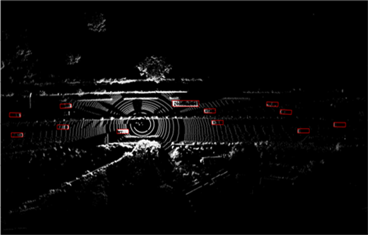
- 라벨데이터: 라이다라벨(.json)
{
"information" :
{
"file_name" : "10001_000.pcd"
},
"annotations" :
[
{
"attribute" :
{
"dimension" :
[
2.0216021537780762,
1.8134353,
5.0109071731567383
],
"instance_id" : 0,
"location" :
[
-3.7326726913452148,
7.1781210899353027,
-1.15421324
],
"track_id" : 1,
"yaw" : 1.553611159324646
},
"class" : "vehicle"
},
{
"attribute" :
{
"dimension" :
[
2.0224957466125488,
1.943546,
5.0222625732421875
],
"instance_id" : 1,
"location" :
[
-1.6528165340423584,
32.988121032714844,
-1.537343543
],
"track_id" : 2,
"yaw" : 1.5895867347717285
},
"class" : "vehicle"
},
{
"attribute" :
{
"dimension" :
[
2.0042130947113037,
1.468624,
4.9666624069213867
],
"instance_id" : 2,
"location" :
[
5.5567803382873535,
-63.237884521484375,
-1.3223454454
],
"track_id" : 3,
"yaw" : 1.6429150104522705
},
"class" : "vehicle"
}
]
} - 이미지 라벨링 포맷
-
데이터셋 구축 담당자
수행기관(주관) : 라이드플럭스
수행기관(주관) 책임자명 전화번호 대표이메일 담당업무 정하욱 064-749-8039 contact@rideflux.com · 사업 총괄 · 데이터 수집 · 데이터 검수 수행기관(참여)
수행기관(참여) 기관명 담당업무 인피닉 · 데이터 라벨링 및 검수 중앙대학교 · 데이터 활용 모델 개발 울산과학기술원 · 데이터 활용 모델 개발
-
인터넷과 물리적으로 분리된 온라인·오프라인 공간으로 의료 데이터를 포함하여 보안 조치가 요구되는 데이터를 다운로드 없이 접근하고 분석 가능
* 온라인 안심존 : 보안이 보장된 온라인 네트워크를 통해 집, 연구실, 사무실 등 어디서나 접속하여 데이터에 접근하고 분석
* 오프라인 안심존 : 추가적인 보안이 필요한 데이터를 대상으로 지정된 물리적 공간에서만 접속하여 데이터에 접근하고 분석 -
- AI 허브 접속
신청자 - 안심존
사용신청신청자신청서류 제출* - 심사구축기관
- 승인구축기관
- 데이터 분석 활용신청자
- 분석모델반출신청자
- AI 허브 접속
-
1. 기관생명윤리위원회(IRB) 심의 결과 통지서 [IRB 알아보기]
2. 기관생명윤리위원회(IRB) 승인된 연구계획서
3. 신청자 소속 증빙 서류 (재직증명서, 재학증명서, 근로계약서 등 택1)
4. 안심존 이용 신청서 [다운로드]
5. 보안서약서 [다운로드]
※ 상기 신청서 및 첨부 서류를 완비한 후 신청을 진행하셔야 정상적으로 절차가 이루어집니다. -
신청 및 이용관련 문의는 safezone1@aihub.kr 또는 02-525-7708, 7709로 문의
데이터셋 다운로드 승인이 완료 된 후 API 다운로드 서비스를 이용하실 수 있습니다.
API 다운로드 파일은 분할 압축되어 다운로드 됩니다. 분할 압축 해제를 위해서는 분할 압축 파일들의 병합이 필요하며 리눅스 명령어 사용이 필요합니다.
리눅스 OS 계열에서 다운로드 받으시길 권장하며 윈도우에서 파일 다운로드 시 wsl(리눅스용 윈도우 하위 시스템) 설치가 필요합니다.
※ 파일 병합 리눅스 명령어
find "폴더경로" -name "파일명.zip.part*" -print0 | sort -zt'.' -k2V | xargs -0 cat > "파일명.zip"
- 해당 명령어 실행 시, 실행 경로 위치에 병합 압축 파일이 생성됩니다.
- 병합된 파일 용량이 0일 경우, 제대로 병합이 되지 않은 상태이니 "폴더경로"가 제대로 입력되었는지 확인 부탁드립니다.
※ 데이터셋 소개 페이지에서 다운로드 버튼 클릭하여 승인이 필요합니다.
